

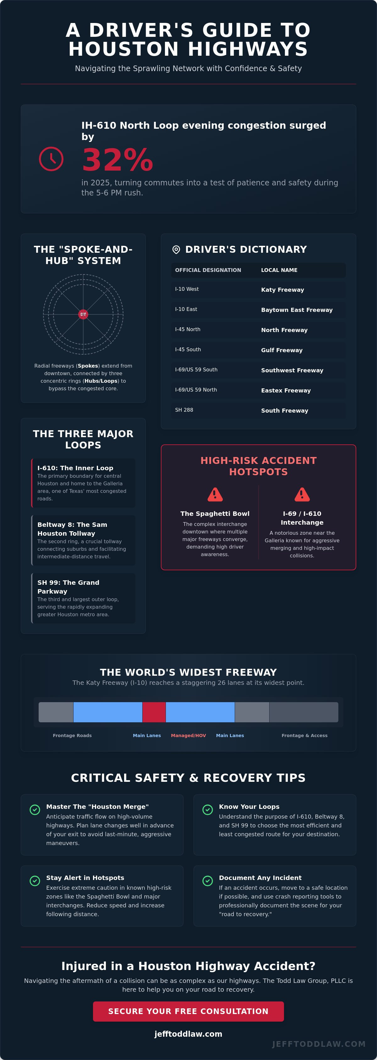
Did you know that evening congestion on the IH-610 North Loop surged by 32% in 2025, turning a standard commute into a grueling test of patience and safety? If you feel like driving on houston highways requires a secret decoder ring to translate "The Katy" from I-10 or "The Loop" from 610, you are not alone. The sheer volume of traffic and the aggressive merging at interchanges like the I-69 and SH 288 split can leave any driver feeling vulnerable and overwhelmed.
At The Todd Law Group, PLLC, we believe that confidence comes from clarity. We promise to help you master the city's complex "spoke-and-hub" system so you can reach your destination with total awareness and peace of mind. This guide provides a clear map of local nomenclature, identifies the most dangerous accident hotspots based on Houston TranStar data, and explains how the 2026 toll increases and I-45 construction projects impact your daily route. Whether you're avoiding the Alabama Street bridge closure or adjusting to the 2026 Move Over laws, we're here to support you on your road to recovery.
Key Takeaways
- Master the "spoke-and-hub" system to navigate the three major concentric loops with confidence and ease.
- Identify high-risk zones like the Spaghetti Bowl and the I-69/I-610 interchange to anticipate traffic patterns and avoid accidents.
- Learn specialized driving techniques, including the "Houston Merge," designed specifically for the unique flow of houston highways.
- Secure your "road to recovery" by knowing exactly how to document an incident safely using professional crash reporting tools.
The Houston Highway System: Understanding the Spoke-and-Hub Network
Houston’s urban sprawl is anchored by a sophisticated engineering layout known as Houston's hub-and-spoke freeway structure. This design utilizes radial freeways that extend outward like the spokes of a bicycle wheel, connected by a series of concentric loops that act as the hubs. The Texas Department of Transportation (TxDOT) manages this massive infrastructure to facilitate the movement of over 2.3 million residents across the metro area. Because the city sits on a vast, flat coastal plain with few natural geographic barriers, engineers have had the rare freedom to expand outward and upward. This has resulted in some of the most expansive houston highways in existence, designed specifically to handle the high volume of commercial and commuter traffic that defines our local economy.
The concentric loops serve a vital purpose in traffic management. They allow drivers to bypass the heavily congested downtown core, which acts as the central axis for almost every major route. As the city continues to grow, these loops have expanded further out, with the Grand Parkway (SH 99) now serving as the third and largest ring. Managing such a vast network requires constant maintenance and oversight from TxDOT, which oversees thousands of lane miles to ensure the structural integrity of our bridges and overpasses.
Designations vs. Common Names: The Houston Driver’s Dictionary
If you're listening to a traffic report, you might hear a broadcaster mention the "Southwest Freeway" or the "Eastex Freeway." To a newcomer, this is often confusing because both names refer to the same highway: US 59. Locals name freeways based on their direction from downtown. US 59 is the Eastex Freeway when you're heading north toward Humble, but it becomes the Southwest Freeway as you travel toward Sugar Land. The ongoing transition of US 59 to I-69 adds another layer of complexity for drivers using GPS systems that might use these designations interchangeably.
- I-10 West: Katy Freeway
- I-10 East: Baytown East Freeway
- I-45 North: North Freeway
- I-45 South: Gulf Freeway
- I-69/US 59 South: Southwest Freeway
- I-69/US 59 North: Eastex Freeway
- SH 288: South Freeway
The World’s Widest Freeway: The Katy Freeway (I-10)
The stretch of I-10 between Beltway 8 and I-610 is globally recognized as the widest among all houston highways. Following a massive expansion completed in 2008, this section reaches a staggering 26 lanes at its widest point, including main lanes, managed lanes, and frontage roads. While the sheer width is an engineering marvel, it creates significant safety hurdles for drivers. Navigating across several lanes to reach a specific exit requires early planning and constant mirror checks. The introduction of managed lanes and HOV requirements helps regulate flow during peak hours, yet the high-speed merging at these entry points remains a common location for high-impact collisions.
Decoding the Three Major Loops: 610, Beltway 8, and Grand Parkway
Houston’s identity is inextricably linked to its three concentric rings. These loops don't just manage traffic; they define the city’s cultural and economic boundaries. A common point of confusion for those new to houston highways is the overlap between historic designations and modern interstate numbers. For example, the signs may indicate I-69, but locals and older maps will still refer to it as US 59. Understanding that these are the same physical road is the first step toward navigating the city without hesitation. As these loops intersect with major "spokes" like I-10 and I-45, they create high-pressure transition zones where awareness is your best defense.
The interaction between these rings allows for a flexible commute, yet each loop carries its own personality and risk profile. While the inner rings are older and more compact, the outer rings are subject to rapid expansion and evolving toll structures. If you've been impacted by a collision on these high-speed routes, seeking guidance from an experienced personal injury advocate can help you secure the resources needed for your recovery.
I-610: The Historic Inner Loop
Commonly referred to as "The Loop," I-610 serves as the primary boundary for central Houston. The West Loop segment, which passes through the Galleria area, consistently ranks as one of the most congested stretches of road in Texas. Data from 2025 indicates that the North Loop saw a 32% increase in PM peak congestion, making it a hotspot for rear-end collisions during the 5-6 PM rush. Drivers should be particularly cautious on the North and South Loop segments, where the highway’s older design includes sharper curves and shorter merging ramps than the newer outer loops. These structural limitations require drivers to maintain a steady speed and avoid late-lane changes.
The Sam Houston Tollway: Beltway 8 Logistics
Beltway 8, or the Sam Houston Tollway, serves as the middle ring and is the lifeblood for suburban commuters. It's managed by the Harris County Toll Road Authority (HCTRA), which implemented new toll rates on January 1, 2026. A standard mainline toll for EZ TAG users is now $1.74, while the Westpark Tollway has reached $1.99. It's vital to distinguish between the free frontage roads and the tolled main lanes to avoid unexpected fees or navigation errors. A frequent cause of accidents on the Beltway involves "toll gantry braking," where drivers unfamiliar with electronic tolling suddenly slow down as they pass under sensors. Maintaining a consistent speed is essential for safety, as most modern tolling in Houston is fully automated and does not require stopping.
Finally, the Grand Parkway (SH 99) represents the massive outer loop that connects distant satellite communities like Katy, The Woodlands, and Sugar Land. As of April 2026, many segments of this loop are still under development or recently completed, offering a smoother but much faster driving experience. Because it covers such vast distances, driver fatigue and high-speed tire blowouts are more prevalent here than on the inner city loops.
Houston's Most Dangerous Highway Hotspots and Interchanges
Safe travel on houston highways requires more than just a working GPS. It demands a heightened sense of situational awareness at specific "danger zones" where infrastructure design meets high-speed traffic. The I-45 and I-10 interchange, famously known as the "Spaghetti Bowl," is a prime example of this challenge. This area forces multiple high-speed lanes to converge into tight, elevated curves, often leaving drivers with only seconds to react to sudden braking or lane changes. Similarly, the Gulf Freeway (I-45 South) maintains a reputation for high-speed collisions due to its aging design. Many of its on-ramps are dangerously short, forcing vehicles to merge into 70 mph traffic with minimal acceleration space.
The I-69 and I-610 West Loop interchange is statistically the most congested corridor in Texas. In 2025, Houston TranStar data showed that peak period delays here reached record levels, with average AM peak delays exceeding 11 minutes for short segments. This congestion isn't just an inconvenience; it's a safety hazard. When thousands of vehicles attempt to cross multiple lanes to reach an exit, side-swipe accidents become almost inevitable. These incidents often occur when drivers realize too late that their lane is exiting, leading to panic-induced maneuvers.
The West Loop and I-69 Interchange: A Commuter’s Nightmare
The weaving patterns at this interchange are particularly hazardous because drivers must often cross three lanes of traffic in less than a quarter-mile. Active construction in 2026 adds to the confusion. For instance, the Alabama Street bridge over I-69 is scheduled for reconstruction from April 30, 2026, until February 8, 2027. Additionally, specific closures like the I-69 Northbound shutdown from May 1 to May 4, 2026, force thousands of vehicles onto unfamiliar detours. These sudden shifts in traffic flow are prime times for accidents. If you suffer an injury in a construction zone, the legal implications are complex. Proving liability requires an understanding of contractor safety protocols, which is why we focus on these details to help you stay on the road to recovery.
I-45 North: The "Hospitality" and Hazard Route
Traveling toward The Woodlands on the North Freeway presents a different set of risks. This route sees a massive volume of heavy trucking traffic sharing lanes with passenger vehicles. When an 80,000-pound rig is involved in a collision, the margin for error disappears. Weather also plays a critical role on this stretch. Houston’s flash floods can turn I-45 into a series of standing water traps in minutes. During heavy rains, visibility drops to near zero, and the high-speed nature of the North Freeway makes hydroplaning a constant threat. We recommend checking real-time incident reports during the spring storm season to avoid these high-risk conditions.
Critical Safety Tips for Navigating Houston’s High-Volume Traffic
Driving on houston highways requires a shift in mindset from passive commuting to active risk management. While the standard "Two-Second Rule" is taught in driver education, it's often insufficient for Houston’s 70+ mph environments. At these speeds, your vehicle travels over 100 feet per second. We recommend increasing your following distance to at least four seconds, especially when traveling on the Katy Freeway or the Grand Parkway. This extra cushion provides the vital reaction time needed when a lead driver suddenly brakes for a missed exit or a debris hazard. If you find yourself in a situation where a collision was unavoidable, our dedicated legal team can help you navigate the complex insurance claims process.
The "Houston Merge" is another local necessity that requires both assertiveness and caution. In heavy stop-and-go traffic, wait for a natural gap and use your signal early, but don't assume other drivers will yield. Zipper merging, where vehicles take turns entering the flow of traffic, is the most efficient method, yet it's often ignored during peak rush hours. Be particularly wary of "Left-Lane Exit" traps. Many older interchanges, such as those connecting I-45 to I-10, feature exits on the left side of the highway. This forces slower traffic to cross high-speed lanes, creating significant friction and increasing the likelihood of high-impact rear-end collisions.
Vehicle breakdowns on a highway with no shoulder are a driver's worst nightmare. If your car becomes disabled in a live lane, do not exit the vehicle to inspect damage or change a tire. Stay buckled in, turn on your hazard lights, and call 911 or Houston TranStar immediately. The risk of being struck as a pedestrian on a high-speed route is extreme, and your vehicle's steel frame is your best protection while waiting for emergency responders.
Dealing with Aggressive Driving and Road Rage
Aggressive driving is a frequent reality on the 610 Loop. You may encounter "tailgaters" or drivers weaving through lanes at excessive speeds. De-escalation is your safest strategy. If a driver is following too closely on the Katy Freeway, move to the right and let them pass. Never tap your brakes to "signal" them or use hand gestures that could provoke an encounter. Road rage incidents can escalate into violence or secondary accidents. Don't stop on the main lanes or the shoulder to confront another driver. Your physical restoration and safety are more important than winning a highway dispute.
Using Technology Safely: TranStar and Beyond
Leveraging technology can help you avoid the most congested houston highways before you even start your engine. The Houston TranStar app provides real-time data on incidents, average speeds, and flood sensor alerts. However, checking your GPS or traffic apps while navigating complex interchanges like the "Spaghetti Bowl" is a major cause of distracted driving accidents. Set your route before you leave and use voice prompts to keep your eyes on the road. Under the expanded Texas "Move Over" law effective in 2026, drivers must vacate the lane closest to stationary emergency vehicles, including animal control and parking enforcement with flashing lights, or face fines up to $2,000 if an injury occurs.
Navigating the Road to Recovery After a Houston Highway Accident
The moments following a collision on houston highways are critical for both your physical safety and your future legal claim. If your vehicle is still operable, Texas law requires you to move it out of the main travel lanes to the nearest shoulder or a safe secondary location. Staying in a live lane on routes like I-10 or I-45 puts you at extreme risk of a secondary, high-speed impact. Once you've reached the shoulder, stay inside your vehicle with your seatbelt fastened until emergency responders arrive. The high velocity of passing traffic makes the roadside one of the most dangerous places for a pedestrian to stand.
Documenting the scene is essential, but it must be done without compromising your safety. We provide a specialized "Crash Report" utility designed to help you capture vital details quickly. Use your phone to photograph vehicle positions, license plates, and any relevant road signs or construction markers. If there are witnesses, try to obtain their contact information before they leave the scene. These pieces of evidence are the foundation of a successful recovery process, especially when dealing with the complex multi-party liability common in high-speed pileups.
Never decline medical evaluation at the scene, even if you feel fine. Adrenaline often masks serious injuries like whiplash, internal bleeding, or traumatic brain injuries that may not manifest symptoms for hours or days. Seeking immediate care creates a professional medical record that links your injuries directly to the accident. Without this documentation, insurance adjusters will likely argue that your suffering was caused by a pre-existing condition or a later event.
The Role of The Todd Law Group, PLLC in Your Recovery
Jeff Todd brings a unique perspective to highway accident litigation, having transitioned from a prestigious career in corporate law to personal advocacy. This "high volume" experience means our firm is uniquely equipped to handle the logistical demands of complex cases involving commercial carriers or multiple jurisdictions. We operate under a "Road to Recovery" philosophy, which means we prioritize your physical and financial restoration while our team manages the aggressive tactics of insurance adjusters. For more detailed information on how we protect your interests, you can explore our guide on Houston car accident lawyers.
Protecting Your Legal Rights on Texas Roads
In the days following a crash, you will likely be contacted by an insurance representative asking for a recorded statement. You are not legally required to provide one immediately, and doing so can inadvertently damage your case. These statements are often used to find inconsistencies that justify a claim denial. Under Texas law, you generally have a two-year statute of limitations from the date of the accident to file a personal injury lawsuit. Waiting too long can permanently bar you from seeking compensation for your losses. If you’ve been injured on a Houston highway, contact The Todd Law Group, PLLC today for a free consultation to ensure your rights remain protected.
Master the Houston Roadway Ecosystem
Navigating the complex layout of houston highways requires a blend of geographical knowledge and active risk management. By mastering the distinction between the three major loops and implementing wider safety margins at interchanges like the I-610 West Loop, you can significantly reduce your risk on the road. It's essential to utilize real-time resources to stay ahead of the multi-year I-45 construction projects and the 2026 toll rate adjustments that impact your daily commute.
If an incident occurs despite your best efforts, you deserve a partner who understands the high-stakes nature of Texas litigation. Founding attorney Jeff Todd has been licensed in Texas since 1994, bringing over 30 years of "high volume" experience to motor vehicle accident claims. We operate on a contingency basis, so there is no fee unless we win your case. Our firm manages every legal detail to ensure your physical and financial restoration remains the priority. Start Your Road to Recovery with a Free Consultation and let us provide the steady reassurance you need to move forward with confidence.
Frequently Asked Questions
Which Houston highway is the most dangerous?
Interstate 45 consistently ranks as the most dangerous highway in Houston and frequently appears on lists of the deadliest roads in the United States. High speed differentials and heavy commercial traffic contribute to a high rate of fatal collisions per mile. While the I-69 and I-610 interchange is the most congested, I-45 sees more high-impact accidents due to its aging infrastructure and narrow lanes in the downtown core.
What is the difference between the 610 Loop and Beltway 8?
The 610 Loop is the innermost ring surrounding the central business district, while Beltway 8 is the middle ring located approximately 12 miles from the city center. Most of the main lanes on Beltway 8 are part of the Sam Houston Tollway, which requires an EZ TAG or another compatible transponder. In contrast, I-610 is a traditional interstate with no toll requirements, though it experiences much higher levels of stop-and-go congestion during peak hours.
How do I get a copy of my Houston highway accident report?
You can obtain a copy of your accident report through the Texas Department of Transportation Crash Records Information System (CRIS) online portal. If the Houston Police Department or Harris County Sheriff's Office responded to your incident on houston highways, you may also request the records directly from their respective departments. Most reports are available for a small fee within 10 days of the incident being filed by the responding officer.
Is the Grand Parkway a toll road all the way around?
The Grand Parkway (SH 99) is a tolled route for nearly its entire 180-mile circumference, with only a few older segments remaining non-tolled. Toll rates are adjusted annually and are managed by both TxDOT and the Harris County Toll Road Authority. As of April 2026, most drivers use electronic tag systems to navigate this outer loop, as cash payment options have been phased out to maintain high-speed traffic flow.
What should I do if my car stalls on a Houston freeway with no shoulder?
Stay inside your vehicle with your seatbelt fastened and immediately call 911 or the Houston TranStar roadside assistance line. Do not attempt to exit the car to check for damage or walk to a nearby exit, as the risk of being struck by passing traffic is extremely high. Turn on your hazard lights and wait for a patrol vehicle or tow truck to provide a safety buffer behind your vehicle.
Who is responsible for maintenance on Houston highways?
The Texas Department of Transportation (TxDOT) is responsible for the maintenance of all interstate and U.S. highways in the region. The Harris County Toll Road Authority (HCTRA) manages the maintenance and operations specifically for the Sam Houston Tollway and other county-managed toll routes. Local city or county public works departments only handle the maintenance of frontage roads and surface streets that intersect with the highway system.
Can I sue the city for a pothole-related accident on a Houston highway?
Suing a government entity for pothole damage is difficult due to sovereign immunity laws that protect the city and state. To be successful, you must prove that the agency had "actual notice" of the specific pothole and failed to repair it within a reasonable timeframe. These cases are complex and typically require a legal advocate to investigate maintenance logs and previous citizen complaints to establish negligence.
How does the "Move Over" law work on Houston freeways?
The Texas "Move Over" law requires you to vacate the lane closest to stationary emergency vehicles or slow down to 20 mph below the posted speed limit. Following legislative updates in 2026, this protection now extends to stationary animal control and parking enforcement vehicles with flashing lights. Failing to comply can result in fines up to $2,000 if your actions lead to an injury of a roadside worker or emergency responder.